Maps
2023 Canadian Distribution of Whitebark and Limber Pine
Recent range maps of whitebark and limber pine (BC & AB)
2019 Whitebark Pine Range Maps
As part of the U.S. National Whitebark Pine Restoration Plan (NWPRP), we recently updated the distribution of the whitebark pine range maps. Our first call requested whitebark pine distribution information from agencies and tribes managing whitebark pine habitat in the U.S. These maps are available here: 2019 WBP Updated Distribution Maps
2014 Whitebark and Limber Pine Range Maps for U.S. and Canadian Distributions
Cyndi Smith (Scientist Emeritus) and Adam Collingwood (GIS Specialist) — Parks Canada, Waterton Lakes National Park, Alberta

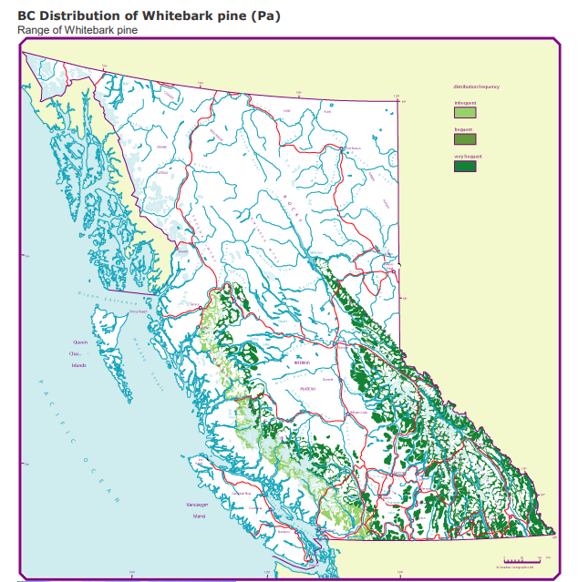
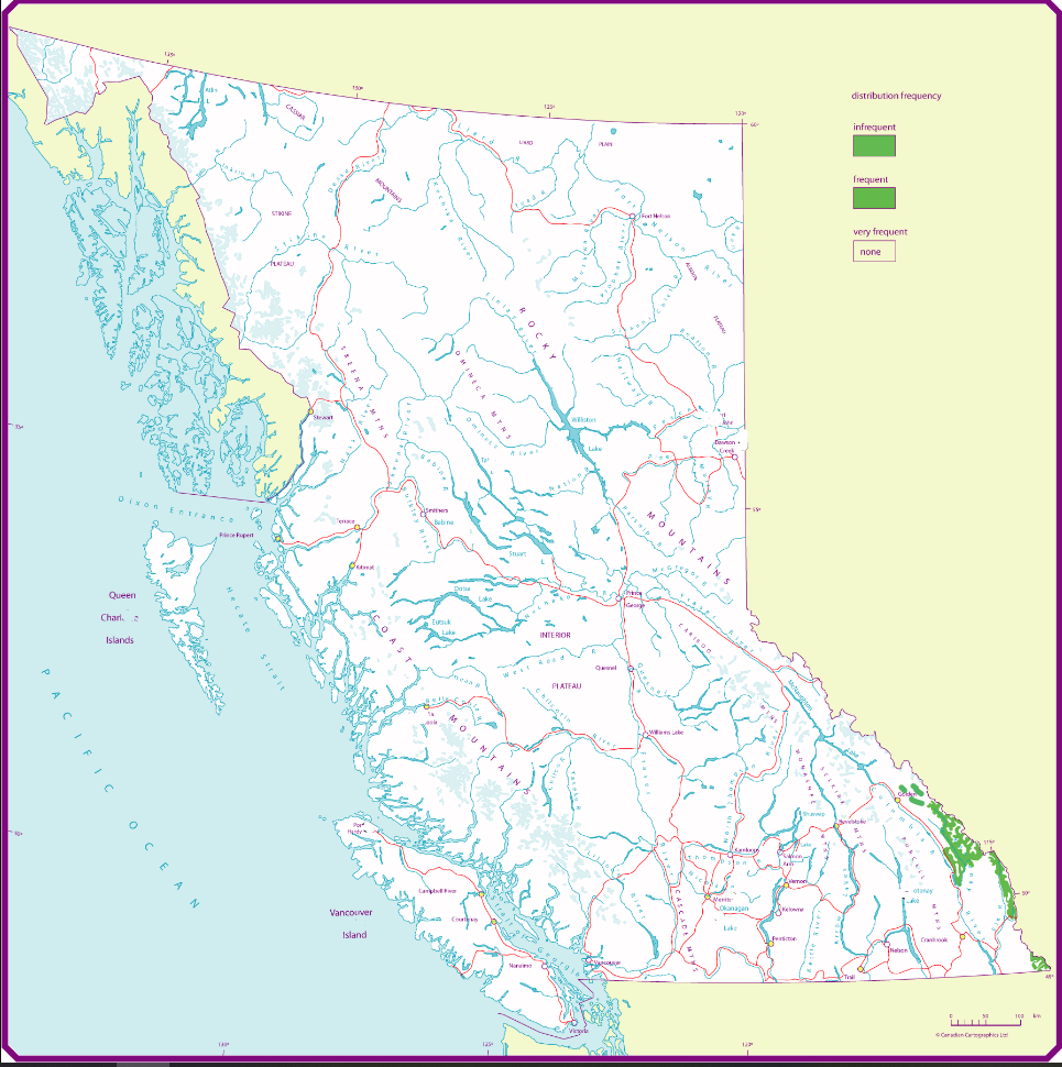
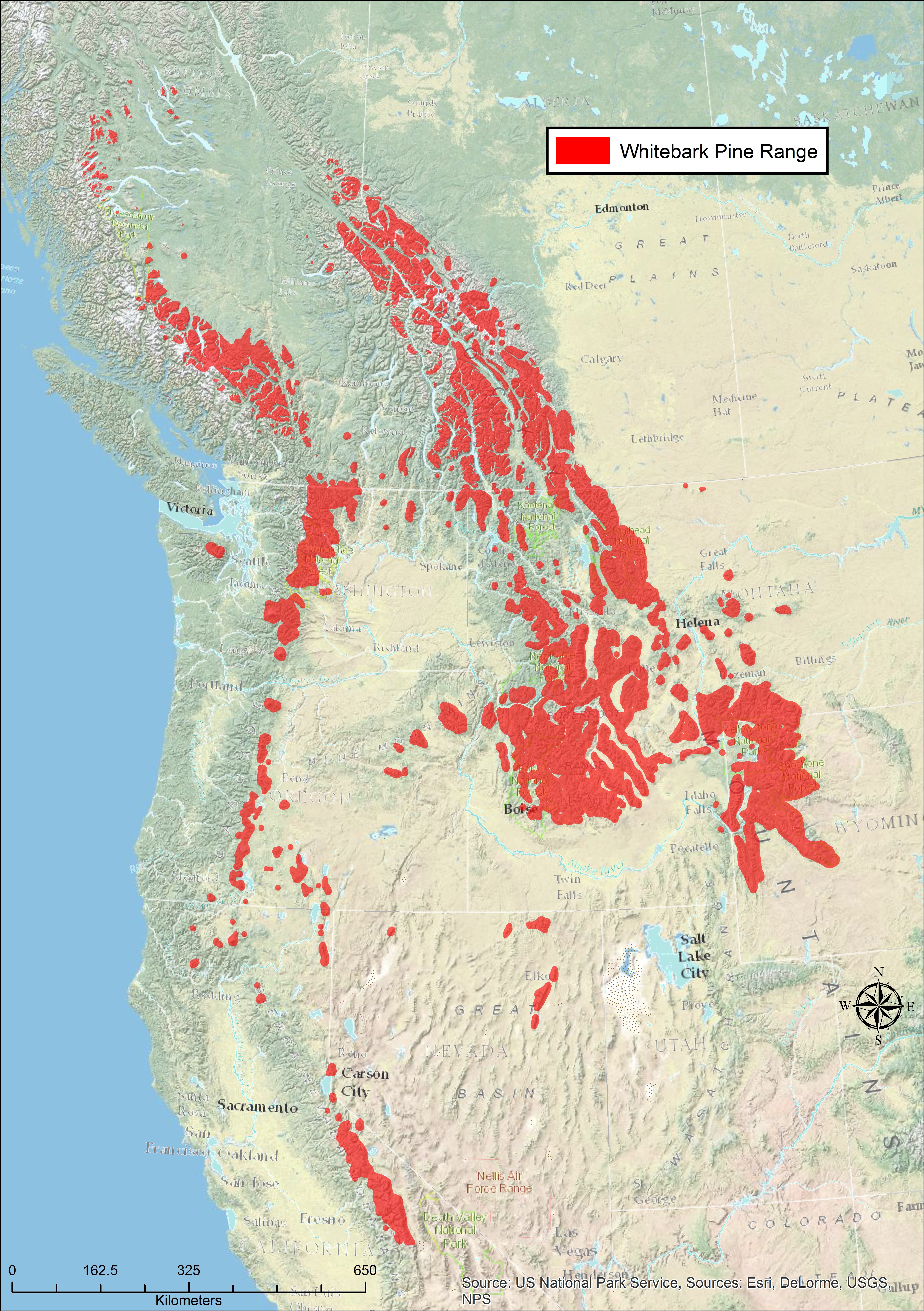
Fig. 1 – Whitebark Pine Range
Whitebark (WBP) and limber (LP) pine are both legally listed as Endangered under The Wildlife Act in the Province of Alberta (Government of Alberta 2010), and WBP is also listed as Endangered in Canada federally under the Species at Risk Act (SARA; Government of Canada 2012). As recovery planning for both species began, it became apparent that existing range maps (e.g., Critchfield and Little 1966, Little 1971, Ogilvie 1989) were misleading and out-of-date in Canada. In particular, portions of the range were mapped with different standards, resulting in large polygons of apparently contiguous occurrence in Canada and a more finely grained pattern of smaller, often disjunct polygons in the U.S.A.
Thus we began the process of building new range maps to a common standard of scale and minimum polygon size. We gathered existing GIS layers from individuals and agencies(ACIMS 2013), applying lower elevational cut-offs (for WBP), and buffering locations of plots, transects and random observations. We then did an iterative process of sending the resulting maps out to field staff for review, tweaking the maps based on responses, and sending them out again. As we solicited information from US colleagues to make a seamless transition across the international border, we were encouraged to expand our work to the entire range for both species in North America, which we did. The improved resolution is especially obvious for whitebark pine (Fig. 1), while the limber pine range had fewer changes (Fig. 2).

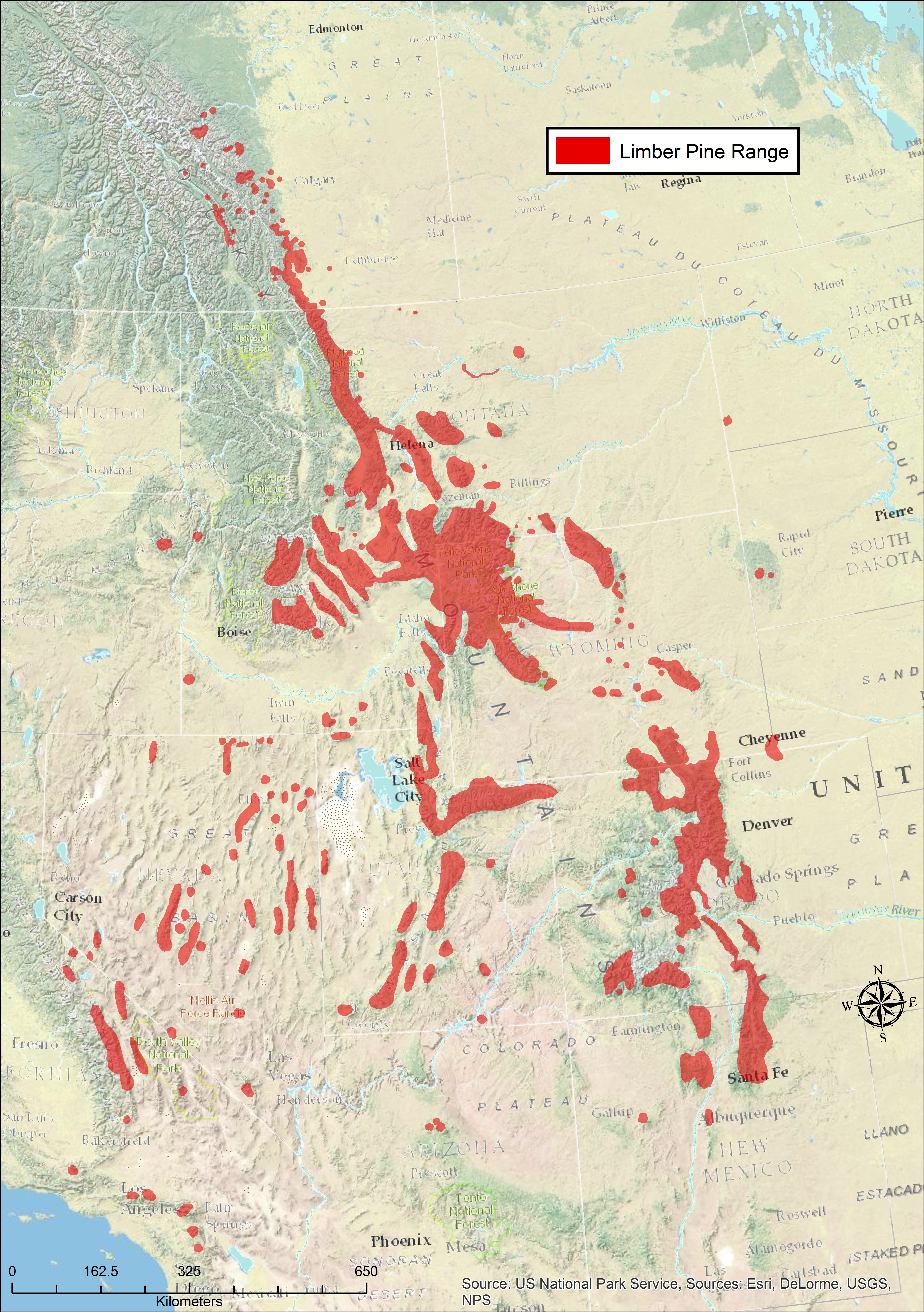
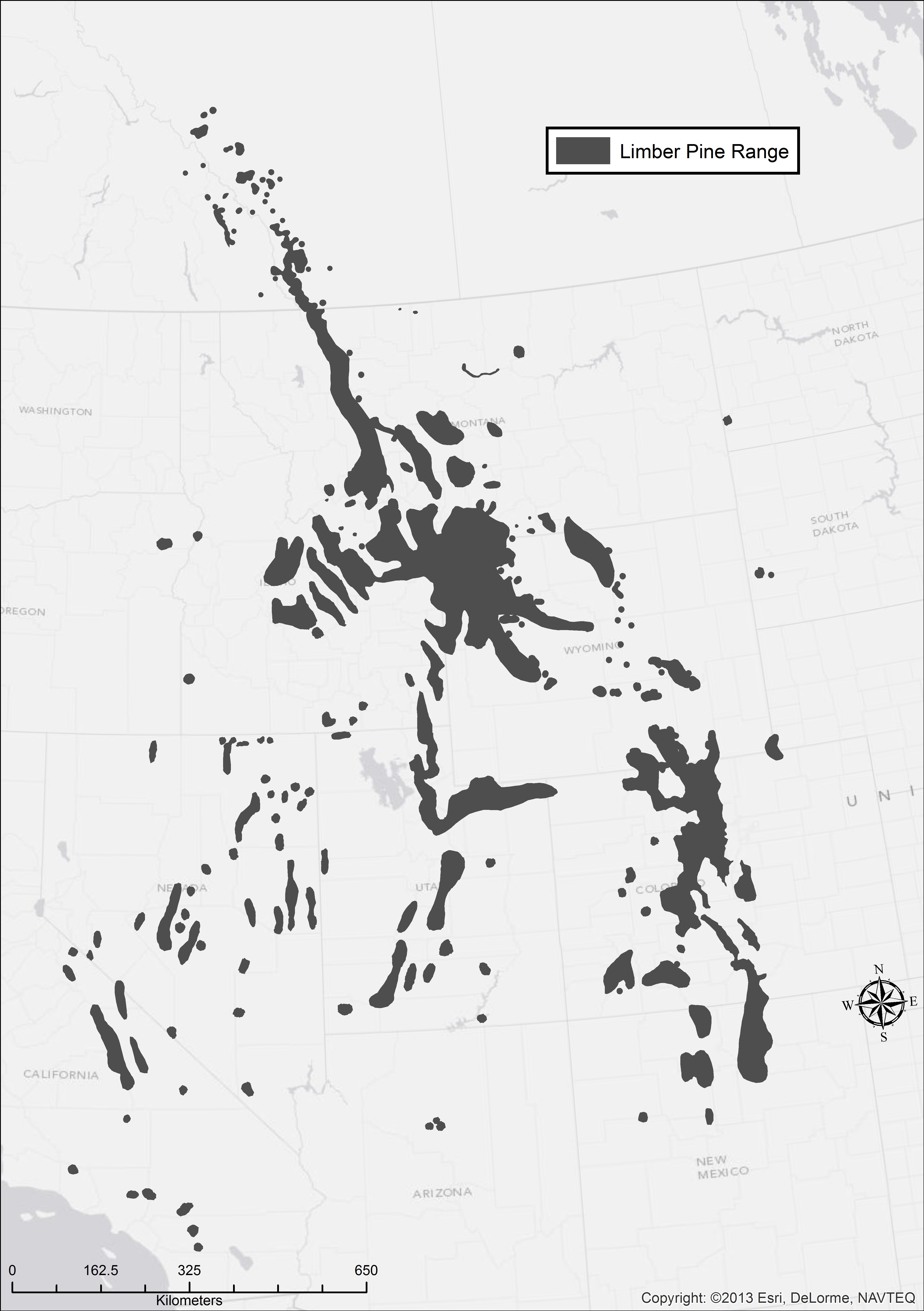
Fig 2 – Limber Pine Range
In the interest of making these maps widely available, and to encourage corrections and feedback, this range map project is being hosted here on the Whitebark Pine Ecosystem Foundation’s website. You will find GIS files in different formats, as well as some ready-to-use range maps in black-and-white and color. Note that these are BROAD scale maps, not suitable at the level of stand mapping, for instance.
Please Provide Feedback
We suggest three ways to provide feedback so that we can continue to improve the accuracy of these maps as new information becomes available:
- copy the shape files, make corrections, then save the files with your name and the date,
- send polygons or point data directly, or
- draw changes on a hard copy and then scan it.
Suggested citation for the shape files: Whitebark Pine Ecosystem Foundation. 2014. Whitebark pine and limber pine range maps. Available online from http:\whitebarkfound.org [accessed date].
Links to download zip files of GIS shapefiles: WBP_Range_2014_v1[1] LP_2014_v1[1]
Images of Maps
Literature Cited
- Alberta Conservation Information Management System (ACIMS). 2013. Online data accessed October 8, 2013. Alberta Tourism Parks and Recreation, Edmonton, AB.
- Critchfield, W.B. and E.L. Little, Jr. 1966. Geographic distribution of the pines of the world. Miscellaneous Publication 991. US Dept. of Agriculture Forest Service, Washington, D.C.
- Government of Alberta. 2010. Species assessed by Alberta’s Endangered Species Conservation Committee: short list [online]. Available from www.srd.alberta.ca/BioDiversityStewardship/SpeciesAtRisk/SpeciesSummaries/ [Accessed 30 July 2010].
- Government of Canada. 2012. Order amending Schedule 1 to the Species at Risk Act. Canada Gazette Part II, Vol 146, No. 14, SOR/2012-113, June 20, 2012 [online]. Available from http://www.sararegistry.gc.ca/virtual_sara/files/orders/g2-14614i_e.pdf [accessed 16 September 2012]
- Little, E.L., Jr. 1971. Conifers and important hardwoods. Volume 1 of Atlas of United States trees. Miscellaneous Publication 1146. US Dept. of Agriculture Forest Service, Washington, D.C
- Ogilvie, R.T. 1989. Distribution and ecology of whitebark pine in western Canada. Pp 54-60 in Proceedings – Symposium on whitebark pine ecosystems; 1989 March 29-31, Bozeman, MT. Compiled by W.C. Schmidt, K. J. McDonald. General Technical Report INT-270
- U.S. Geological Survey. 2013. Digital representations of tree species range maps from “Atlas of United States trees” by Elbert L. Little, Jr. (and other publications). http://esp.cr.usgs.gov/data/little/. [Accessed April 2014].
Figure Captions
- Figure 1. New range map of whitebark pine in North America superimposed on the old range map by E. L. Little, Jr. (U.S. Geological Survey 2013).
- Figure 2. New range map of limber pine in North America superimposed on the old range map by E. L. Little, Jr. (U.S. Geological Survey 2013).
Acknowledgements
The following individuals assisted in constructing the new range maps for Whitebark and Limber Pine in Smith & Collingwood (2014), by reviewing maps, providing shape files or data points.
- Peter Achuff | plachuff@gmail.com | 403-653-4966 | Waterton Lakes National Park (Retired)
- Andrew Bower | abower@fs.fed.us | 360-956-2405 | Olympic National Forest
- Elizabeth Campbell | Elizabeth.Campbell@NRCan-RNCan.gc.ca | 250-298-2368 | Natural Resources Canada
- Tony Chang | tony.chang@msu.montana.edu | 406-997-2670 | Montana State University
- Alana Clason | ajclason@gmail.com | Bulkley Valley Research Centre
- Adam Collingwood | adam.collingwood@pc.gc.ca | 403-859-5124 | Waterton Lakes National Park
- Tom DeSpain | tdespain@fs.fed.us | 509-684-7225 | USDA Forest Service Genetic Resource Program
- Joyce Gould | joyce.gould@gov.ab.ca | 780-427-7702 | Alberta Tourism, Parks and Recreation
- Robin Gutsell | Robin.Gutsell@gov.ab.ca | 780-644-1154 | Alberta Environment and Sustainable Resource Development
- Sybille Haeussler | Sybille.Haeussler@unbc.ca | 250-847-6082 | Bulkley Valley Research Centre
- Gregg DeNitto | gdenitto@fs.fed.us | 406-329-3637 | USDA Forest Service Forest Health Protection
- Andrew Hansen | hansen@montana.edu | 406-994-6046 | Montana State University
- Greg Harris | gregharris@fs.fed.us | 208-765-7407 | Idaho Panhandle National Forest
- Marcus Jackson | mbjackson@fs.fed.us | 406-329-3282 | USDA Forest Service Forest Health Protection
- Brad Jones | brad.jones@gov.ab.ca | 403-355-4854 | Alberta Environment and Sustainable Resource Development
- Randy Moody | randy@keefereco.com | 250-421-7910 | Moody Tree
- Michael Murray | Michael.Murray@gov.bc.ca | 250-354-6852 | BC Ministry of Forests, Lands and Natural Resource Operations
- Brenda Shepherd | brenda.shepherd@pc.gc.ca | 780-883-0341 | Jasper National Park
- Cyndi Smith | cyndi.smith9@gmail.com | 403-653-4966 | Waterton Lakes National Park (Retired)
- Eric Smith | elsmith@fs.fed.us | 970-295-5841 | USDA Forest Service Forest Health Technology Enterprise Team
- Joanne Vinnedge | Joanne.Vinnedge@gov.bc.ca | 250-996-5262 | BC Ministry of Forests, Lands and Natural Resource Operations
- Drajs Vujnovic | Drajs.Vujnovic@gov.ab.ca | 780-427-7159 | Alberta Tourism, Parks and Recreation
- Brendan Wilson | bwilson@selkirk.ca | 250-363-1393 | Selkirk College
- Art Zack | azack@fs.fed.us | 208-765-7418 | Idaho Panhandle National Forest